LAND RESOURCE INVENTORY AND GIS DATABASE FOR FARM, VILLAGE AND BLOCK LEVEL PLANNING
Implementing agencies
Soil and Crop Management Studies, Tamil Nadu Agricultural University, Coimbatore
Department Of Agriculture, Chennai
Agricultural Engineering Department, Chennai
Executive Summary
The challenges in agriculture are to increase the productivity per unit area and to prevent the severity of various forms of degradation. The twine challenges of preventing degradation and increasing productivity of the shrinking land resource can be addressed by adopting site specific and viable land management technologies suitable for each and every parcel of the land in a village. For this, a detailed GIS database on soil and other secondary resources covering each and every plot of a survey number occurring in a village is required. When the database is created in a GIS mode, it can be updated and collated with other secondary data for making farm level agricultural planning and strategies.
The project will be implemented in ten blocks of Ariyalur (Tirumanur), Coimbatore (Annur), Dharmapuri (Pappireddipatti), Dindugal (Oddanchatrum), Krishnagiri (Uthangarai), Namakkal (Rasipuram), Perambalur (Perambalur), Ramnad (R.S.mangalam), Salem (Veerapandi) and Villupuram (Gingee) districts which are selected based on the agricultural activities and rural setting.
The project will be jointly implemented by Agricultural Engineering Department (AED), Department of Agriculture (DOA) and Tamil Nadu Agricultural University (TNAU). AED will generate digital base maps. DOA will generate soil maps & TNAU will analyze the soil samples & create GIS database. The total outlay of the project is Rs. 360 lakhs. The AED component will be Rs. 19.14 lakhs, DOA component will be Rs. 208.11 lakhs & TNAU component will be Rs. 132.75 lakhs.
Block level soil resources inventory along with village soil and thematic maps will be generated in both hard copy and digital formats. The database will help the farmers and extension workers for selection of potential crops for the farm holdings, application of soil and crop specific fertilizers, reclamation of problem soils, selection and use of correct agricultural inputs and use of suitable agricultural machineries and tools. The database will provide the basis for all the activities related to transfer of technologies in agriculture. The database can be interfaced with other resources databases on climate, socio-economic conditions and marketing facilities etc., and there by enabling the Government in making policy decisions at village and block levels.
ACTIVITY WISE AGENCIES INVOLVED AND BUDGET ESTIMATE
(In lakh rupees)
Activity No. |
Activity |
AED |
DOA |
TNAU |
1 |
Preparation of base map |
|
|
|
|
1.1 Procurement of SOI toposheets, Cadastral maps / Village maps Digitization of Cadastral maps |
19.14 |
|
|
|
1.2 Procurement of satellite data |
|
|
15.68 |
2 |
Preparation of field soil map |
|
|
|
|
2.1 Technical assistance |
|
78.04 |
|
|
2.2 Camp office |
|
11.15 |
|
|
2.3 Traveling allowance |
|
26.01 |
|
|
2.4 Vehicle hire charges |
|
58.07 |
|
|
2.5 Profile and mini-pit examinations and collection of profile and surface soil samples |
|
17.42 |
|
3 |
Analysis of soil samples |
|
|
87.10 |
4 |
GIS database |
|
|
23.23 |
5 |
Preparation of soil resources inventory report |
|
11.61 |
|
6 |
Other Contingencies |
|
|
|
|
6.1 For field operations |
|
5.81 |
|
|
6.2 For lab analyses |
|
|
6.74 |
|
Total |
19.14 |
208.11 |
132.75 |
|
Total budget for the ten blocks (3,60,000 Ha.) |
|
360.00 |
Detailed report
1. Background
The food security we enjoy, though comforting at present, is not sufficient to meet all the needs of all the people in the State. There is no room for complacency and we have to increase our agricultural output manifold in the future to meet the growing demands of our burgeoning population which is expected to double in another 20 to 25 years time.
The area under cultivation in Tamil Nadu is less than 50 per cent of the total geographical area and there is not much scope for expansion of area under agriculture in the near future. So, undoubtedly, the required increase in agricultural production has to come only from the already cultivated areas. Even this available arable land area is shrinking because of diversion of productive land to non-agricultural purposes and competing demands of various land uses. Added to this is the effect of degradation, which has already affected about six million hectares of land in the State. Soil erosion, salinity and alkalinity and depletion of nutrients has reached to such a magnitude in many areas of the State that taking up amelioration is not economical anymore thereby threatening the sustainability of the land resource base for agriculture.
The twin challenges of preventing degradation and increasing productivity of the shrinking land resources can be faced effectively by adopting rational, site-specific and viable land use options suitable for each and every parcel of land at village level. For this we need a detailed database covering each and every plot and survey number occurring in a village.
2. Project Rationale
Soil resource information in Tamil Nadu is available only at Taluk level at the scale of 1:50,000. This information is useful only for regional planning. But we need a village level database for a long time and effective implementation of all technologies and agricultural developmental programme at farm level. The micro level database at farm level can only help in identifying farm specific problems and potentials and to provide technologies and amelioration measures for increasing the agricultural production. Further the micro level database on land resource will serve as an important decision making agricultural planning and implementation of soil and crop related management technologies. The farm level decisions with GIS database include selection of potential crops for the farm holdings, application of soil and crop specific fertilizers, reclamation of problem soil, selection and use of correct agricultural inputs and use of suitable agricultural machineries and tools. The GIS database developed under this project can be interfaced with other resources databases on climate, socio-economic conditions and marketing facilities etc., and there by enabling the Government in making policy decisions at village and block levels. Therefore the project can be conceived as a common denominator project on natural resources and expected to provide not only a comprehensive database of a village but to integrate various kinds of information and to provide complete solution to the multitudes of problems faced by the farmers and various development agencies engaged in the agricultural and rural development programmes in a block.
3. Project strategy
Based on the agricultural activity and rural setting, one block in each of the ten districts will be selected for undertaking detailed soil resources inventory. The blocks proposed for the first year of the project period are Thirumanur, Annur, Pappireddipatti, Ottanchatram, Uthangarai, Rasipuram, Perambalur, R.S.Mangalam, Veerapandi and Gingee blocks in Ariyalur, Coimbatore, Dharmapuri, Dindugal, Krishnagiri, Namakkal, Perambalur, Ramnad, Salem and Villupuram districts, respectively (Figure 1). The soil resources inventory will be initiated with the digital base map created from SOI toposheet, cadastral map at 1:4,000 to 1:8,000 scale and satellite data. Intensive field traversing to identify soils at farm level will be done. In selected transects, profiles will be located at closely spaced intervals to take care of any change in the land features like break in slope, erosion, gravel, stones, etc. On an average about 300 profiles will be collected in every 1,00,000 ha. Based on the profile study and mini-pit examinations and soil analysis data, the soils will be grouped into different soil series (soil management units). Data on climate, water resources, socio-economic parameters, existing infrastructure and marketing facilities will be collected at village level. Land use particulars at farm level will be collected for revenue records. The soil resource information will be collated with other secondary database for the preparation of thematic maps for different application purposes.
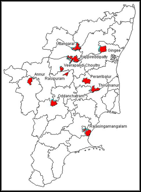
Figure 1. Area of operation
4. Project Goals
a. Preparation of GIS database on soils and land resources at farm level
b. Identification of farm specific constraints affecting crop production
c. Development of management strategies for increasing productivity at farm level
d. Facilitation of the farmers on the use of right kind of inputs and machineries and tools
e. Development of electronic soil and land resource database for implementation of Government schemes
5. Project Components
The project has the following five components and the details are presented below.
5.1 Preparation of village level base map
5.2 Generation of farm level soil map
5.3 Soil analysis and interpretation
5.4 Creation of GIS database at village level
5.5 Block level soil resources inventory report along with village soil maps
5.1 |
Preparation of village level base map |
a. |
Purpose
To provide an authentic reference map for reference during field traversing and for entering field observations and marking the boundary of soil units |
b. |
Objectives
To provide the basis for GIS database development and village level soil map preparation |
c. |
Outputs
Village level base map containing detailed natural and man made features and survey boundaries |
d. |
Performance targets
Agricultural Engineering Department will procure required toposheets and cadastral maps and digitize the base map after extracting the features from the source maps. This will be completed in a period of two months. Satellite data will be procured from National Remote Sensing Agency by TNAU and this will be digitally incorporated with the base map |
e. |
Activities
Procurement of SOI toposheets, Cadastral maps
Digitization of Cadastral maps
Procurement of satellite data |
5.2 |
Generation of farm level soil map |
a. |
Purpose
To conduct field survey and collect site characteristics and soil samples for detailed analysis and provide required information for incorporation in the village level soil map |
b. |
Objectives
To prepare village level soil map for farm level planning |
c. |
Outputs
Village level soil map containing detailed soil resources information at farm level |
d. |
Performance targets
Department of Agriculture will carry out the field traversing and collect soil site characteristics and soil samples for detailed analysis. This will be started in five blocks one each in Ariyalur, Coimbatore, Dharmapuri, Dindugal and Krishnagiri districts and completed in four months. Second set of five blocks one each in Namakkal, Perambalur, Ramnad, Salem and Villupuram districts will be completed in another four months period. Soil samples will be analyzed by TNAU in phase with survey work. |
e. |
Activities
Field traversing
Collection of soil site characteristics and profile study
Collection of profile and surface soil samples |
5.3 |
Soil analysis and interpretation |
a. |
Purpose
To carry out detailed soil analysis and interpret the data for facilitating soil classification and for detailed characterization of soil resources at farm level |
b. |
Objectives
To provide soil analytical data for incorporation in the soil survey report and soil data base |
c. |
Outputs
Analytical input for soil characterization and soil database |
d. |
Performance targets
Soil samples will be analyzed by TNAU in phase with survey work and the data will be provided for the report preparation GIS database development. |
e. |
Activities
Soil sample analysis
Interpretation of analytical results
Incorporation of soil analysis data in the GIS database |
5.4 |
Creation of GIS database at village level |
a. |
Purpose
To offer informed decision making capabilities for farm level planning and for implementing agricultural developmental programmes at village and block level |
b. |
Objectives
To create GIS database at village level |
c. |
Outputs
Village level GIS database |
d. |
Performance targets
After the completion of the soil resource survey in each block, the GIS database will be completed in the next two months period by TNAU. |
e. |
Activities
Digitization of village level soil map
Creation of GIS database by incorporating soil resource information at farm level and the secondary data collected during the survey at village level |
5.5 |
Block level soil resources inventory report along with village soil maps |
a. |
Purpose
To assemble information collected about the soil resources at village level for ready reference and future updating |
b. |
Objectives
To prepare Block level soil resources inventory report along with village soil maps |
c. |
Outputs
Village level GIS database |
d. |
Performance targets
After the completion of the soil resource survey, the report will be completed in the last two months period of the project by DOA in consultation with TNAU. |
e. |
Activities
Compilation of survey details at village and block level
Preparation of soil survey report
Preparation of soil atlas containing thematic maps at village level |
6. Project cost and financing for 2007-08
Activity wise agencies involved and budget estimate (in lakh rupees)
Activity No. |
Activity |
AED |
DOA |
TNAU |
1 |
Preparation of base map |
|
|
|
|
1.1 Procurement of SOI toposheets, Cadastral maps / Village maps Digitization of Cadastral maps |
19.14 |
|
|
|
1.2 Procurement of satellite data |
|
|
15.68 |
2 |
Preparation of field soil map |
|
|
|
|
2.1 Technical assistance |
|
78.04 |
|
|
2.2 Camp office |
|
11.15 |
|
|
2.3 Traveling allowance |
|
26.01 |
|
|
2.4 Vehicle hire charges |
|
58.07 |
|
|
2.5 Profile and mini-pit examinations and collection of profile and surface soil samples |
|
17.42 |
|
3 |
Analysis of soil samples |
|
|
87.10 |
4 |
GIS database |
|
|
23.23 |
5 |
Preparation of soil resources inventory report |
|
11.61 |
|
6 |
Other Contingencies |
|
|
|
|
6.1 For field operations |
|
5.81 |
|
|
6.2 For lab analyses |
|
|
6.74 |
|
Total |
19.14 |
208.11 |
132.75 |
|
Total budget for the ten blocks (3,60,000 Ha.) |
|
360.00 |
Worksheet on cost estimate is furnished wide Annexure I
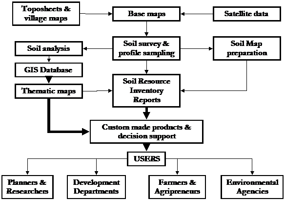
Figure 2. Activity, products and users
7. Reporting
The monthly progress report and annual report will be submitted to the Department of Agriculture by incorporating the inputs from Agricultural Engineering Department and TNAU. The soil resource inventory report in standard format will be prepared by Department of Agriculture and this will be the major component of the final report. Financial statements and certificates will be submitted to department of Agriculture by the individual agencies for the funds received by them.
IMPLEMENTATION GUIDELINES
1. Role of participating organizations in implementing the project
Agricultural Engineering Department (AED) will procure required toposheets at 1:25000 scale and cadastral / village maps. These maps will be digitized after extracting the required features from the source maps. The base maps will be geo-referenced with an accuracy required at the scale of the original. Digital toposheets will be procured if available. These base maps will be supplied to Department of Agriculture (DOA) for carrying out field survey. The digital version of the village maps with field parcels will be supplied to Tamil Nadu Agricultural University (TNAU) for creating GIS database with soil information.
Department of Agriculture will carry out the field traversing and collect soil site characteristics and soil samples for detailed analysis. The base map supplied by AED and satellite data and soil analytical data supplied by TNAU will be utilized by the DOA for preparing the soil map and soil survey report.
Tamil Nadu Agricultural University will procure and interpret and supply the satellite data with interpretation to DOA. This will hasten the field work and improve the accuracy of soil boundary delineation. Analysis of soil samples and water samples supplied by the DOA from the survey area will be undertaken by TNAU. The analytical results will be supplied to the DOA. From the final soil map and interpretations, GIS database for the surveyed blocks will be developed.
2. Measurable outcome, bench mark and milestones
Detailed block level soil survey report with village wise soil map and cadastral level GIS database on soil and water quality will be available for the selected 10 blocks.
Work Flow
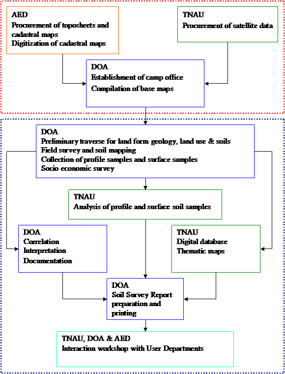
3. Methodology
The execution of the project will involve the following operational steps.
3.1. Collection of cadastral maps, toposheets, satellite images, geological maps, climatic data, land use particulars and earlier soil survey reports - All the maps, reports and any other information pertaining to the selected survey area will be collected and analysed to determine the status of the existing database, gaps in information and the need for additional data collection.
3.2. Identification of personnel required and preparation of action plan - Since it is a multidisciplinary work, the organizations and personnel required to execute the project in a time-bound manner for the selected area is essential and accordingly an action plan, specifying the role of selected persons and time required to execute the assigned work will be prepared in advance for the project area.
3.3. Preparation of base maps -The scale and type of base map selected for survey is very important because that will decide the amount of information that can be depicted on the map. The larger the scale used, more will be the information available and vice-versa. For Farm Planning in Tamil Nadu, with small and fragmented holdings, cadastral maps (scales ranging from 1: 4000 to 1: 8000), showing field boundaries and survey number, are most suitable for base maps. Use of high-resolution large-scale satellite images available at present in India for base map is a possibility but due to the absence of field boundaries, they can be used only in conjunction with the cadastral maps in the present project.
3.4. Field investigations: Detailed field investigations will be carried out by following the standard methodology, to collect the required information on soils, land use, cropping pattern, management practices and socio-economic status of each farm and house holding in the survey area. In addition to the above, required data on other land characteristics will be collected, either during the course of the field investigations or separately later. The steps involved in carrying out the field survey for various land characteristics are detailed below:
3.4.1. Soil Survey
- Base map preparation and updating the base map
- Preliminary traversing and identification of major landforms
- Selection of transects, profile· study in transects and random observations
- Grouping of soils based on soil-site characteristics into soil series
- Collection of soil samples and laboratory analyses
- Classification and mapping- traversing and drawing boundaries on the cadastral map with phases of soil series as mapping unit
3.4.2. Socio-economic survey
Socio-economic survey will be conducted through a questionnaire and the required data will be collected from farmers and other sections of the society in the village.
3.4.3. Collection of data on other land characteristics
Data on rainfall and other climatic parameters, land use, crops grown at present and cropping pattern practiced, and data on any other land characteristics that influences the use of the land will be collected, mostly along with the socio-economic survey. Only in some cases will survey be conducted separately to collect the required data on the above parameters.
3.5. Identification of constraints and potentials affecting the land use
The constraints and potentials like soil erosion, slope, depth of the soil, coarse fragments, soil texture, salinity and alkalinity, fertility etc will be delineated and shown separately, in the form of single theme maps for the surveyed area or shown collectively as land capability maps, indicating the general capability of the area for agriculture and other purposes.
3.6. Developing soil- site suitability criteria for crops and other land uses
This is very important if the resources are to be assessed for specific land uses. The suitability criteria cannot be evolved by anyone specialist and the process· needs a multidisciplinary team. The criteria for specific land use is established from the available information and data derived from the experimental results specific to the selected land use.
3.7. Evaluating the land for existing and promising land uses
This will be done by following the guidelines and principles given by the Food and Agriculture Organization (1976) to assess the land resources for specific kinds of land use.
3.8. Identification of viable and sustainable land use types
The evaluation or suitability assessment will show the suitability or otherwise of the various land uses selected for the area. Based on the degree of suitability and prevailing economic condition, the best and sustainable land use can be selected easily.
3.9. Finalization of land resource and land suitability maps.
3.10. Preparation of draft report and thematic maps.
3.11. Identification of Benchmark sites for periodical monitoring.
3.12. Organization and integration of data in a GIS framework
3.13. Finalization and printing of maps and reports.
3.14. Organizing Workshops to disseminate the results to the user agencies.
4. Database in GIS Framework
All the spatial and non-spatial data, generated at village level, will be converted into digital form and integrated in a GIS framework. The database at village level will be abstracted further to block, and finally to the state and integrated with suitable GIS configuration. This data handling system, with its storage, retrieval, analysis and display capability, will be a very valuable tool to the planners, administrators, extension workers and other land users for making any land use decisions and for providing proactive advice to the farmers on a real time basis. The flow of data and its integration in a GIS framework is indicated in the following flow chart.
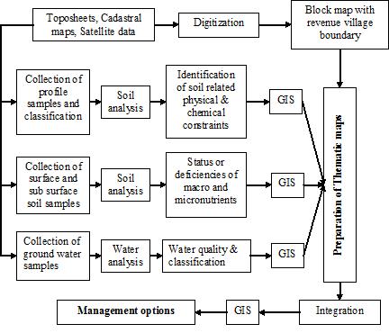
Integration of Data in a GIS Framework
5. Mile stones
- Base map
- Preliminary Soil map
- Soil analytical data
- Correlation
- Final soil map
- Interpretation
- Digital database
- Soil survey report
- Interaction workshop with User Departments
6. Reporting of progress
Individual agencies involved in the programme implementation will report the monthly physical and quarterly financial progress to Commissioner of Agriculture for forwarding the same to the Executive Director, TAWDEVA.
7. Monitoring
- AED: The work of AED Team involved in this project will be monitored by Chief Engineer or the Officer(s) identified by the Chief Engineer
- TNAU: The Director, CSCMS, TNAU will monitor the TNAU Team involved in the project work
- DOA: The survey team and other staff members of the DOA involved in the project work will be monitored by the respective controlling officers and the concerned JDAs of the project area as and when the DOA Team is working in their jurisdiction.