MANGROVES OF INDIA
The word "Mangrove" is considered to be a combination of the Portuguese word "Mangue" and the English word "grove". Mangroves are salt-tolerant plants of tropical and subtropical intertidal regions of the world. The specific regions where these plants occur are termed as 'mangrove ecosystem'. These are highly productive but extremely sensitive and fragile. Besides mangroves, the ecosystem also harbours other plant and animal species.
Anthropological pressures and natural calamities are the enemies of the ecosystem. Growing industrial areas along the coastlines and discharge of domestic and industrial sewage are polluting these areas. Many studies have highlighted these problems and the conservation efforts are being considered.
Experiences have proved that the presence of mangrove ecosystems on coastline save lives and property during natural hazards such as cyclones, storm surges and erosion. These ecosystems are also well known for their economic importance. They are breeding, feeding and nursery grounds for many estuarine and marine organisms. Hence, these areas are used for captive and culture fisheries. The ecosystem has a very large unexplored potential for natural products useful for medicinal purposes and also for salt production, apiculture, fuel and fodder, etc.
The distribution of mangrove ecosystem on Indian coastlines indicates that the Sundarban mangroves occupy very large area followed by Andaman-Nicobar Islands and Gulf of Kachch in Gujarat. Rest of the mangrove ecosystems is comparatively smaller. However, good number of studies has been carried out in almost all ecosystems. Over 1600 plant and 3700 animal species have been identified from these areas.
THREATS TO MANGROVE ECOSYSTEM |
|
The threats to the mangrove ecosystem could be broadly grouped into two: Natural and Anthropogenic. These factors may affect the system as a whole or any one entity within the system, etc. The natural threats include: Climatic changes, Cyclones and Physical processes. Diseases, deterioration, pollution, grazing, agriculture, aquaculture and human encroachment (including reclamation), etc., are considered as the anthropogenic threats to the ecosystem.
According to a status report of the Government of India publication, the total area of the mangroves in India, was reckoned at about 6,740 km2. This covered about 7% of the world mangroves (Krishnamurthy, 1987) and 8% of the Indian coastline (Untawale, 1987). But a recent Indian Remote Sensing Data (Nayak, 1993) showed that the total area of the mangroves decreased to 4,474 km2 (Table. 1). The values shown by satellite data shows a decrease in the mangrove area, which may be due to several reasons such as
- grazing by domestic cattles and exploitation of mangrove woods for fuel and timber
- the neo-tectonic movement of river courses
- abatement of upstream freshwater discharges due to construction of dams and reservoirs
- rapid trend of reclamation of mangrove forests for habitations
- pollutant discharges from cities and industries etc.
Recent data available from State of Forest Report 2011 of the Forest Survey of India, Dehra Dun shows that mangrove cover in the country is 4,662.56 sq.km, which is 0.14 percent of the country's total geographical area. The very dense mangrove comprises 1,403 sq.km(30.10 % of the mangrove cover), moderately dense mangrove is 1,658.12 sq.km (35.57%) while open mangroves cover an area of 1,600.44 sq.km (34.33%). Compared with 2009 assessment, there has been a net increase of 23.34 sq.km in the mangrove cover of the country. This can be attributed to increased plantations particularly in Gujarat state and regeneration of natural mangrove areas.
STATE/UT WISE MANGROVE COVER 2011 (Area in km²) |
|
S. No |
State/UT |
Very Dense Mangrove |
Moderately Dense Mangrove |
Open Mangrove |
Total |
Change w.r.t. 2009 assessment |
1 |
Andhra Pradesh |
0 |
126 |
226 |
352 |
-1 |
2 |
Goa |
0 |
20 |
2 |
22 |
5 |
3 |
Gujarat |
0 |
182 |
876 |
1058 |
12 |
4 |
Karnataka |
0 |
3 |
0 |
3 |
0 |
5 |
Kerala |
0 |
3 |
3 |
6 |
1 |
6 |
Maharashtra |
0 |
69 |
117 |
186 |
0 |
7 |
Orissa |
82 |
97 |
43 |
222 |
1 |
8 |
Tamil Nadu |
0 |
16 |
23 |
39 |
0 |
9 |
West Bengal |
1038 |
881 |
236 |
2155 |
3 |
10 |
Andaman & Nicobar |
283 |
261 |
73 |
617 |
2 |
11 |
Daman & Diu |
0 |
0.12 |
1.44 |
1.56 |
0.34 |
12 |
Pondicherry |
0 |
0 |
1 |
1 |
0 |
Total |
1403 |
1658.12 |
1601.44 |
4662.56 |
23.34 |
Mangroves in Tamil Nadu exist on the Cauvery deltaic areas. Pichavaram has a well-developed mangrove forest dominant with Rhizophora spp., Avicennia marina, Exocaria agallocha, Bruguiera cylindrica, Lumnitzera racemosa, Ceriops decandra and Aegiceras corniculatum as the dominant flora. Mangroves also occur near places like Vedaranyam, Kodiakarai (Point Calimere), Muthupet, Chatram and Tuticorin. Inspite of the fact that Pichavaram mangrove is very small in area, it has been very well studied in all aspects of studies like biology, chemistry, microbiology etc. by the scientists of the Centre of Advanced Study in Marine Biology, Department of Botany and Faculty of Agriculture of Annamalai University and also M.S. Swaminathan Research Foundation, Chennai.
DISTRICT WISE MANGROVE COVER IN TAMIL NADU (2011) |
|
S. No. |
Districts of Tamil Nadu |
Very Dense Mangrove |
Moderately Dense Mangrove |
Open Mangrove |
Total |
Change w.r.t. 2009
assessment |
1 |
Chidambaranar |
0 |
0 |
7 |
7 |
0 |
2 |
Cuddalore |
0 |
9 |
10 |
19 |
0 |
3 |
Nagapattinam |
0 |
2 |
1 |
3 |
0 |
4 |
Ramanathapuram |
0 |
5 |
3 |
8 |
0 |
5 |
Thanjavur |
0 |
0 |
2 |
2 |
0 |
Total |
0 |
16 |
23 |
39 |
0 |
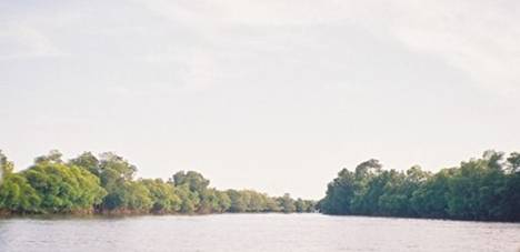
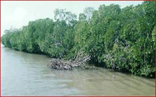
Pichavaram mangrove forest is located about 200 km south of Chennai (Madras) city in the southeast coast of India. This mangrove is actually sandwiched between two prominent estuaries, the Vellar estuary in the north and Coleroon estuary in the south. The Vellar - Coleroon estuarine complex forms the Killai backwater and Pichavaram mangroves.
Pichavaram mangrove is present in the higher land of Vellar-Coleroon estuarine complex. The mangrove extends to an area of 1,100 hectares, representing a heterogeneous mixture of mangrove elements. The source of freshwater to this mangrove is from both the estuaries and that of seawater is Bay of Bengal.
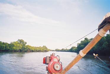
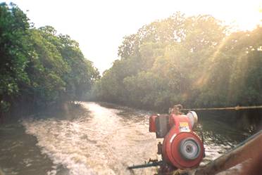
The whole of the mangrove comprises about 51 small and large islands with their sizes ranging from 10 m2 to 2 km 2. The mangrove soil usually consists of alluvium derived from the mangrove plants. About 40% of the total area is covered by water ways, 50% by forest and the rest by mud flats, sandy and salty soils. There are numerous creeks, gullies and canals traversing the mangroves with a depth ranging from 0.5 to 1.5 m and discharging freshwater into the system. A major irrigation channel is mainly discharging agricultural waste water from the entire upper reaches to this mangrove.
Pichavaram mangrove did not receive much attention during pre and post independence periods. A map published by the Cuddalore District authorities in 1882 is the document which was first made available to public. Then, only during the later part of 20th century (Thirumalairaj, 1959) explored the Pichavaram mangrove and Venkatesan (1966) listed the floral communities in the region in relation to environmental factors.
French institute, Pondicherry is one of the pioneering institutes in exploring Pitchavaram and contributed several publications on the wealth of the mangroves (Blasco, 1975; Meher Homji, 1979)). The Centre of Advanced Study in Marine Biology, right from its inception in 1961 has been involved in various research activities in Pichavaram mangrove. Water quality, floral and faunal composition, microflora, ichthyofauna, bioactive substances from mangroves, fishery resources, larval development, heavy metals and organochlorine residues, methanogens, cyanobacteria, wood biodeterioration and UV - radiation are all studied extensively by this Centre. During 90s, M.S. Swaminathan Research Foundation (MSSRF), Chennai, India established a mangrove Genetic Resource Conservation Centre here by adopting 50 ha forest area. In addition, Centre for water Resources, Anna University, Chennai has remotely sensed Pichavaram forest with satellite imageries
The mangrove flora in India comprises 35 species under 16 genera and 13 families. Of these 33 species (16 genera and 13 families) are present along the east coast (Kathiresan, 1998). The east coast of India and Andaman and Nicobar islands show high species diversity.
Pichavaram mangrove is one of the rare mangrove forests in India and it represents 14 exclusive mangrove species (Kannupandi and Kannan, 1998). Avicennia marina alone constitutes nearly 30% of the total population followed by Bruguiera cylindrica (17%) and Avicennia officianalis (16%). The population density of other species is poor and many of the species are on the verge of total extinction.
According to a recent statistics, it is found that nearly 62.8% of the Pichavaram mangrove forests were degraded between 1897 and 1994.
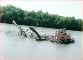
Tissot (1987) investigated the change that has taken place in the vegetation of the Kaveri delta over a period of 2000 years. It has been found that the breadth of the beach protecting the mangrove areas from wave action at Pichavaram mangrove has reduced by 550 m between 1970 and 1992.
The substantial reduction in the forest cover is due to frequent cyclones atleast every alternate year which devasted several mangrove species and reduced the total area from 4000 ha in the beginning of the century to nearly 1100 ha at present.
As a result of this, many plants previously recorded from Pichavaram mangrove have completely vanished. For example, the pollen analysis of the sediments from Pichavaram showed that Sonneratia was abundant here in the past (Caratini et al., 1973), which is on the verge of extinction at present. Further, occurrence of Aegiceras flordium reported from this area by Krishnamurthy (1978) could not be confirmed by Muniyandi (1985). Certain species like Xylocarpus granatum, Rhizophora stylosa and Bruguiera gymnorrhiza which were once collected from this mangrove are not available at present (Kannupandi and Kannan, 1998). It is also found that most of the individuals of Rhizophora sp. are aged and the rate of reproduction is also low at Pichavaram mangrove. It seems to be on its way to extinction at this mangrove, being replaced by the much more dynamic Avicennia marina (Kannupandi and Kannan, 1998).
From the Pichavaram mangrove ecosystem about 100 species of diatoms, 20 species of dinoflagellates, 40 species of tintinnids, 30 species of copepods, 30 species of prawns, 30 species of crabs, 30 species of molluscs and 200 species of fish have been recorded (Anon, 1987).
It is calculated that 8 tonnes of organic plant detritus per hectare per year is produced by the withered mangrove leaves in Pichavaram mangrove. These leaves are colonized by bacteria and fungi, which in turn is eaten by protozoans. All these give rise to rich particulate organic matter, forming the source of food the several animals like crabs, worms, shrimps, small fishes which in turn form prey to more than 60 spices of larger fish living here. Several species of small organisms live inside the proproot system, which form the food for post larvae, juvenile and adult fishes and prawns like Penaeus indicus, P. monodon, P. semisulcatus, Metapenaeus dobsoni and M. monoceros. The mangroves are used as breeding grounds for the prawns like Macrobrachium spp. and certain fish.
An earlier study of the food web pattern (Prince Jeyaseelan, 1981) shows that 67 species of fishes belonging to 51 genera and 33 families are living in this area. Commercially important fish species belonging to the family Mugilidae, Chanidae, Clupeidae, Pomodasyidae and Gerridae are harvested from this mangrove. Seeds for aquaculture of fish and prawn species are available in plenty.
Innumerable studies are available on the chemical aspects of this mangrove from 1960's that is from the coming into existence of the Centre of Advanced Study in Marine Biology of Annamalai University. Simultaneous investigations on the Vellar - Coleroon estuarine complex, all the four aquatic biotopes viz., the mangrove waterways, the adjacent Killai Backwater, the Vellar and Coleroon estuaries and the neritic waters of Bay of Bengal, revealed that certain environmental and meteorological factors exert remarkable influence in this mangrove biotope (Anon, 1987).
With normal (130 cm) and abundant (>130 cm) rainfall, the mouths of the mangrove and estuaries become deep and remain well open to receive considerable volume of neritic inflow particularly at high tide and hence the mangrove ecosystem function more like a coastal marine ecosystem, whereas in the lean years of rainfall, the mangrove ecosystem functions more like a freshwater or limetic ecosystem.
The neritic influence in the mangroves is felt for a distance of about 10 kms. The maximum depth in the waterways is about 1 m. The salinity varies from 0 to 34 ppt. The annual temperature range was from 20 to 34ºC. The pH ranges between 7.60 - 8.50 showing the alkaline nature of the water. The dissolved oxygen content was on an average about 4.5 ml/l.
With regard to pollution studies, the earlier works done by Ramadhas et al. (1975), Sundararaj (1978) Ramadhas (1977), Subramanian (1982), Subramanian et al (1981, 1983) are worth mentioning.
Subramanian (1982) and Subramanian et al. (1983) found that the salt excreting type of mangrove Avicennia marina accumulate more of iron and phosphorus in the leaves than the salt excluding species Rhizophora mucromata and also found a clear seasonal fluctuation. Subramanian (1982) found very clear seasonal fluctuation in the concentrations of Fe, Mn, Cu and Zn in the environmental compartments such as dissolved, particulate and sediment fractions and found the sediments of mangrove which is normally rich in organic matter as a prime sink for these elements that are being brought in by freshwater. Generally the reactive forms of trace elements in the water was higher during monsoon season in this mangrove indicating the importance of freshwater in enriching these waters with essential nutrients.
The animals like the oyster Crassostrea madrasensis , the polychaete Nereis costae had their higher concentrations of trace elements in the monsoon months. Again, in the case of mangrove plants also, salinity seemed to be the dominant factor in controlling the uptake and accumulation of the elements (Subramanian, 1982). A recent data obtained from Pichavaram mangrove on several physico-chemical parameters (Table.2) showed that this mangrove is still pristine and the values are very much within optimal levels (Balasubramanian, 2000 Personal communication).
Earlier workers like Karthikeyan (1988) revealed their concern after finding considerable concentrations of the pesticides like DDTs, Lindane (g-HCH) and Heptachlor in the environmental and biological samples collected from the Pichavaram mangrove and the adjacent Vellar estuary. Later, the recent works of Babu Rajendran (1997), Babu Rajendran and Subramanian (1997), Ramesh et al. (1990; 1991) showed that the concentrations in the Vellar - Coleroon estuarine complex (comprising the Pichavaram mangrove) did not increase in the past decade.
Inspite of the increased usage in the past decade, the concentrations of DDTs (Dichloro diphenyl trichloro ethane) and HCHs (Hexachlorocyclohexane), the two major pesticides which have been used until recently in India, their levels in the Pichavaram mangrove water and sediment are within normal limits. There was a clear seasonal variation showing the clearing away of these volatile residues via. monsoonal rains or atmospheric passage (Takeoka et al., 1991).
MANAGEMENT PERSPECTIVES OF PICHAVARAMN MANGROVE |
|
The research work done by the scientists of the Centre of Advanced Study in Marine Biology and M.S. Swaminathan Research Foundation showed that contamination by various chemicals is not in abnormal levels and is not adding any pressure on this mangrove ecosystem.
TSUNAMI & PICHAVARAM MANGROVES |
|
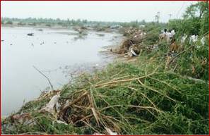
Pichavaram mangrove wetland, occupying an area of about 1400 ha, is located about 280 km down south of Chennai, in the Cuddalore District. Fishing and farming communities belonging to 17 hamlets utilize the resources of the Pichavaram mangrove wetlands of Cuddalore District. Out of these 17 hamlets, 6 hamlets are under physical coverage of the mangrove wetlands, 5 hamlets are located on or near to the open beach and not protected by mangroves. Remaining 6 hamlets are far away from mangrove forest. There was no damage to 6 hamlets that are physically protected by the mangroves but hamlets located on or near to the beach have been totally devasted.
Field visit was made to the Pichavaram mangroves and no major damage was noticed; a few trees located very close to the sea uprooted. All the hydrogen sulphide loaded soil and debris deposited on the forest floor are washed away, which will have positive impact on mangroves. Pichavaram mangrove forest protected hamlets namely, T.S.Pettai, Vadakku Pichavaram, Therkku Pichavaram, Meenavar Colony, MGR Nagar and Kalaingar Nagar against the fury of tsunami. Total families in these hamlets are about 1228 and total population is about 6191. These hamlets are located between 100 m to 1000 m from mangroves. In these hamlets seawater has not entered into the village and there is no loss of property. However, 4 women belonging to MGR Nagar, who were fishing nearby the sea were washed away and died. It is seen that mangrove trees in rows located close to the sea got uprooted due to the impact of the tsunami and beyond that there is no damage. It seems mangrove forest reduced the impact of the tsunami by two ways: a) velocity of the tsunami water greatly reduced after it entered into the mangroves due to friction created by thick mangrove forest and b) volume of water reaching a point is greatly reduced since tsunami water, after entering into the mangroves, is distributed to all the canals and creeks that are present all over the mangroves. A number of fishers who were fishing in the nearby the sea but moved into mangrove water after seeing huge wave of about 10 to 15 feet coming to the beach experienced these. One of the fishers said, "we saved the mangroves by restoring them and it saved our life and property by protecting us" of about 10 to 15 feet coming to the beach experienced these.
DAMAGE TO MANGROVE RESOURCE USER HAMLETS |
|
Some of the fishing families belonging to hamlets such as Muzhukkuthurai, MGR Thittu, Chinnavaikal, Pillumedu, Kannagi Nagar and Mudasalodai fish in the mangrove water seasonally and a few families annually. Since these hamlets are located either near to mangroves, thereby not under the physical cover of the mangroves or on the beach they are devasted by the tsunami. Some of the hamlets such as MGR Thittu, Chinnavaikal, Pillumedu and Kannagi Nagar are located about 50m from the high tide line. These hamlets are first developed as temporary settlements.
IMPACT
The following are the impact of the tsunami in the above-mentioned hamlets.
- Loss of lives
- Loss of and damage to fishing gears and crafts
- Loss of thatched houses with mud walls and huts
- Damage to houses
- Loss of all livestocks
- Loss of all household items, including cooking vessels
- Loss of personal properties including jewels and hard cash
- Loss of textbooks and other items of school students
- Total salinization of lands and water resources, including drinking water.
As a long-term measure we may take up the following activities :
- Building people's institution
- Poverty alleviation programmes
- Self-help groups
- Mangrove plantation in an area of about 500 ha
- Village Knowledge Centres
ROLE OF MANGROVE FORESTS OF PICHAVARAM AS FISH NURSERIES |
|
An account of the food web pattern of 67 species of fishes, belonging to 51 genera and 33 families, of the Pichavaram mangrove ecosystem, is given. Of these, 32 species were omnivores, 30 species carnivores, and only 5 species herbivores. The food of the omnivores consisted of varying combinations of plant, animal and detrital materials. Strict detritus-feeders were absent, although about 88% of omnivores take detritus as part of food. This could be a result of the shallowness of the channels (usually from 40 to 150 cm depth) and high detritus potential of the ecosystem. The occurrence of considerable percentage (about 45%) of carnivorous fishes might be related to the impressive availability of the prey population like the prawn larvae and juveniles and nematodes and copepods and amphipods. Due to high suspended materials in the water, the penetration of sunlight into the channels would restrict the growth of microflora, algae, seaweeds and plants. The nature of the substratum was not conducive to a thick growth and colonisation of plants, like algae and seaweeds. Hence herbivore proportion of fish population was minimum.
Source:
1.Jeyaseelan, M.J.P.; Krishnamurthy, K. Proc. Indian Natl. Sci. Acad. (B: Biol. Sci.). 46(1); 1980; 48-53. 0129.
2.MSSRF Tsunami Report
3. Sources: http://www.mangroveindia.org/
4. State of Forest Report-2005, Forest Survey of India.
|