Landslides
Landslide Mitigatory Measures
Landslides
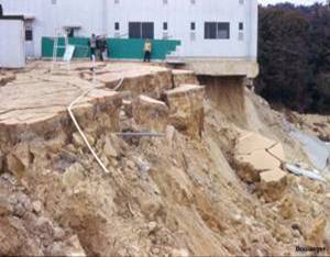
Landslides are simply defined as the mass movement of rock, debris or earth down a slope and have come to include a broad range of motions whereby falling, sliding and flowing under the influence of gravity dislodges earth material. They often take place in conjunction with earthquakes, floods and volcanoes. At times, prolonged rainfall causing heavy block the flow or river for quite some time. The formation of river blocks can cause havoc to the settlements downstream on it's bursting. In the hilly terrain of India including the Himalayas, landslides have been a major and widely spread natural disaster the often strike life and property and occupy a position of major concern
The two regions most vulnerable to landslides are the Himalayas and the Western Ghats. The Himalayas mountain belt comprise of tectonically unstable younger geological formations subjected to severe seismic activity. The Western Ghats and nilgiris are geologically stable but have uplifted plateau margins influenced by neo- tectonic activity. Compared to Western Ghats region, the slides in the Himalayas region are huge and massive and in most cases the overburden along with the underlying litho logy is displaced during sliding particularly due to the seismic factor.
Incidences of Landslides in India
| Region |
Incidences of Landslides |
|
|
Himalayas |
High to very high |
North-eastern Hills |
High |
Western Ghats and the Nilgiris |
Modern to high |
Cattle lost |
Low |
Vindhayachal |
Low |
Landslides Zonation Mopping is a modern method to identify landslides prone areas and has been in use in India since 1980s The major parameters that call for evaluation are as follows:
- Slope-Magnitude, length and Direction
- Soil thickness
- Relative relief
- Land use
- Drainage- pattern and density
- Landslide affected population
Causes of Landslides
Landslides can be caused by
1. Poor ground conditions
2. Geomorphic phenomena
3. Natural physical forces
4. Quite often due to heavy spells of rainfall coupled with impeded drainage.
A Checklist of Causes of Landslides Ground Causes
- Weak, sensitivity, or weathered materials
- Adverse ground structure (joints, fissures etc.)
- Physical property variation (permeability, plasticity etc)
Morphological Causes
• |
Ground uplift (volcanic, tectonic etc) |
• |
Erosion (wind, water) |
• |
Scour4. Deposition loading in the slope crest. |
• |
Vegetation removal (by forest fire, drought etc) |
Physical Causes
•
|
Prolonged precipitation |
• |
Rapid draw- down |
• |
Earthquake |
• |
Volcanic eruption |
• |
Thawing |
• |
Shrink and swell |
• |
Artesian pressure |
Man- made Causes
• |
Excavation (particularly at the toe of slope |
• |
Loading of slope crest |
• |
Draw -down (of reservoir) |
• |
Deforestation |
• |
Irrigation |
• |
Mining |
• |
Artificial vibrations |
• |
Water impoundment and leakage from utilities |
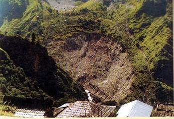
An overall evaluation of the pattern and nature of landslide2 occurrences in the Kerala part of Western Ghats and its corresponding eastern flank falling within Tamil Nadu reveals the following main features:
•
|
Almost all mass movements occur during monsoons (SW and NE monsoon) in the western flank of western Ghats and during occasional cyclonic events in the eastern flank indicating that main triggering mechanism is the over- saturation of overburden caused by heavy rains |
• |
There seems to be a relation between intensity of rainfall and slope failures. |
• |
Majority of the catastrophic mass movements is confined to the overburden without affecting the underlying bedrock. |
• |
Improper land use practices such as heavy tilling, agricultural practices and settlement patterns have contributed to creep and withdrawal of toe support in many cases |
• |
A common factor noticed in most of these vulnerable slopes deforestation in the recent past, cultivation of seasonal crops and increase in settlements. |
• |
In all the vulnerable slopes terracing/ contour bounding is adopted mainly to prevent soil erosion and to enhance percolation during dry season for cultivation of cash crops as well as seasonal crops. Invariably, in all these cases, natural drainage lines on slopes are blocked or modified without adequate provision for surface drainage of excess storm water during high intensity rains prevalent in the area. |
• |
In some areas developmental activities like construction of buildings, road cutting, embankments, cut and fill structures causes modification of natural slopes, blocking of surface drainage, loading of critical slopes and withdrawal to toe support promoting vulnerability of critical slopes. |
Source:
www.boloji.com/environment
|